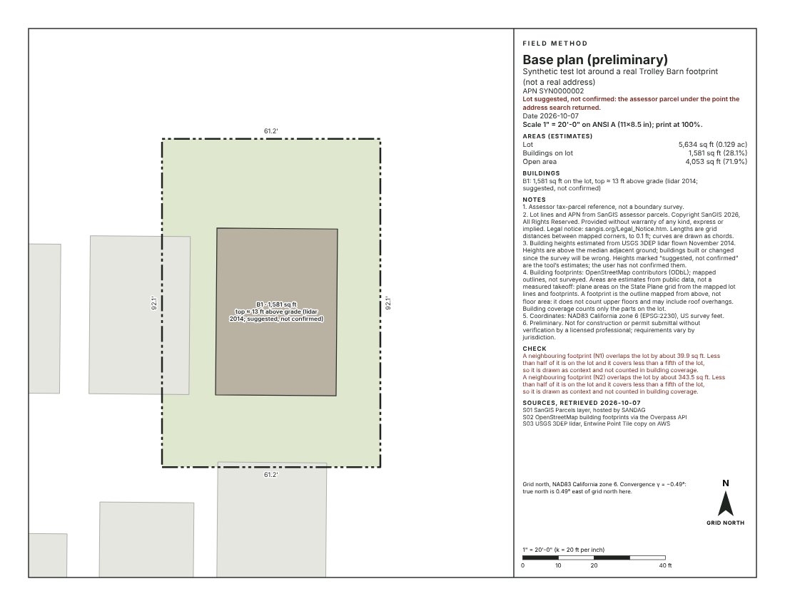
A base drawing before anyone has measured the site
Most residential projects start from a base plan: the lot lines, the house and the yard at a known scale. Before a survey exists, that drawing is usually traced by hand from aerial photos and the assessor’s map. Base Plan draws it from the same public records, says where each line and number came from, and marks what is an estimate.
How it works
- Find the lot. Search an address, or zoom in until parcel outlines appear and click them. Click one parcel or several; click again to take one out. A parcel under an address search result is suggested, not confirmed until you confirm it or click its outline.
- Build the base plan. The app reads the building footprints near the lots and USGS lidar over them, measures each building’s height from the lidar and draws the plan.
- Check and correct. Each lidar height is a suggestion until you confirm it or type your own. Flags explain why a height may be wrong (trees, a newer building, a sloping lot).
- Take it further. Print the sheet, download the DXF, or choose Open in Material Studio to continue with materials and an estimate on the 3D model.
From a Site Dossier, Make a base plan of this lot opens Base Plan at the dossier’s point.
What you get
- Plan sheet
- Letter or 11×17, landscape, at the largest engineering scale that fits (1" = 10' to 60'): lot lines with lengths to 0.1 ft, buildings with their footprint area and estimated height, neighbouring lots and buildings, an area table, grid north with the convergence angle, a scale bar, notes and sources. Print at 100%.
- Areas (estimates)
- Lot, buildings on the lot and open area, per lot and in total when you choose several. A footprint is the outline mapped from above, not floor area.
- CAD linework (DXF)
- R12 or 2004, in NAD 83 California Zone VI (EPSG:2230), US survey feet, with layer names in the NCS format (the property-line layer name is not checked against the NCS text).
- 3D model (GLB)
- Each building as a flat-topped block at its height, the open area draped on the lidar ground, in metres with Y up, for Material Studio or any glTF viewer. Material Studio receives it directly, with the plan as a to-scale image in its markup view.
Where the data comes from
- Parcels: SanGIS assessor parcels, served by SANDAG. Copyright SanGIS 2026, All Rights Reserved. Provided without warranty of any kind, express or implied. Legal notice: sangis.org/Legal_Notice.htm. Only the outline, the APN and the parcel ID are read; no owner information.
- Building footprints: OpenStreetMap contributors (ODbL), or FEMA and ORNL USA Structures (CC BY 4.0) where OpenStreetMap has none.
- Heights and ground: USGS 3D Elevation Program lidar, from the public copy on AWS. The year it was flown is printed on the sheet; buildings changed since then will be wrong.
- Address search: OpenStreetMap Nominatim. Optional imagery: USDA NAIP via USGS The National Map.
Each plan lists its sources with the date they were read, their owner and terms.
Limitations
- Parcel lines are an assessor tax-parcel reference, not a boundary survey or legal description. Not for construction or permit submittal without verification by a licensed professional; requirements vary by jurisdiction.
- Areas and heights are estimates from public data, not a measured takeoff. No accuracy has been measured against a survey.
- Buildings are flat-topped blocks; no roof shapes, hardscape, planting, trees, setbacks or zoning yet.
- San Diego County only. A selection of up to 20 parcels; lidar is not read when the area’s box exceeds 40 acres.
Not yet tested
This is a draft. Its code was tested with automated checks and in headless Chromium, with USGS lidar read for real but the parcel, footprint, address and imagery services replaced by test data, because they could not be reached from the build environment. It has not yet been checked against a real house or a survey, opened in a CAD program, or used in Safari or Firefox. Please send what you find.
Questions
Is it free?
Yes, while it is a draft.
Is anything uploaded?
No. The app runs in your browser; it asks public services for the data around your lot and keeps nothing on a server. Opening the model in Material Studio passes it through this browser’s own storage.
Related: Site Dossier · Material Studio