Start a site with the public record in one place
Before design starts, someone gathers terrain, soils, water, fire hazard, climate and planting context from a dozen agencies, each with its own map, date and format. The result often lives in screenshots that lose their sources.
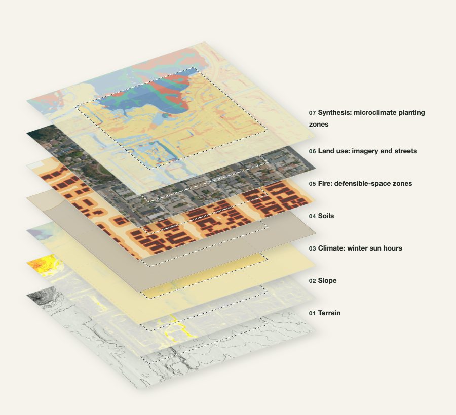
Site Dossier assembles that public record for one point into a numbered record, each layer with its source and date, and lays the layers over one another, as Ian McHarg did in Design with Nature (1969). A team starts from the same evidence and can see where it came from.
It is for landscape architects, architects, planners and designers at pre-design and site analysis. It is a starting record, not a survey.
How it works
- Choose a point. Search for an address or place, or click the map. Choose a study area of 400, 800 or 1,600 ft square; the sheets and files cover it plus a quarter of its width on each side.
- Build the dossier. Your browser requests public data for that area from the agencies’ services and analyzes the terrain. It takes about a minute.
- Read the layers. Turn layers on and off in the overlay viewer and read the sections, each with its sources.
- Print and download. Print the sheet set, download the DXF or the LAS, or copy a link that opens the same dossier.
What you get
- Numbered dossier
- Nine sections in the order the work runs: location and base, terrain, sun and climate, soils, water, fire, synthesis, next steps and an evidence register that lists every source with its date. An overlay viewer stacks imagery, terrain, slope, aspect, 2 ft contours, sun hours on both solstices, soils, streams, fire hazard and defensible-space zones and microclimate planting zones in one frame.
- Draft planting palettes
- Native species by microclimate zone for the coast, the foothills, the mountains and the desert, chosen from the point’s EPA ecoregion and checked against the palette’s elevation band. They are drafts for review; confirm water use on WUCOLS and local suitability on Calscape.
- Base sheets
- Ten sheets with U.S. National CAD Standard sheet IDs (G-001, L-101 to L-107, L-601, G-002), printed to PDF from your browser. Choose the sheet size (ANSI A to E, ARCH A to E including E1, ISO A4 to A0 or a custom size; ARCH D, 24×36 in, by default), landscape or portrait, and a plot scale, or let the preview fit the map to the sheet at a standard engineering or metric scale.
- CAD linework (DXF)
- R12, which states its units in the notes, or 2004, which also records the units and layer lineweights in the file. Layer names follow the NCS layer-name format; choose the layer groups. Coordinates are NAD 83 California Zone VI (EPSG:2230) in US survey feet, or a local origin near the site.
- Lidar point cloud (LAS)
- USGS 3D Elevation Program (3DEP) lidar points over the same area as the DXF, as LAS 1.2: all returns, ground only, or all but noise. Coordinates as the DXF; heights NAVD 88 in US survey feet; USGS classes kept.
- Shared link
- The link keeps the point, the study area, the project name and the sheet size, orientation, plot scale and plan-sheets-only choice. DXF and lidar options are not kept.
For the point cloud, the preview checks which USGS surveys cover the area, newest first. It downloads the newest survey with points there. Where that survey covers less than 95% of the area and an older one covers at least 5 percentage points more, or a survey cannot be read, it asks which to download. Each file holds one survey: surveys can differ in date, point density and accuracy, so they are not combined.
Where the data comes from
- Terrain and imagery: USGS 3DEP elevation (best available resolution when the dossier is built), USGS The National Map imagery and USDA National Agriculture Imagery Program (NAIP) aerial photographs.
- Soils and water: USDA NRCS Soil Survey Geographic Database (SSURGO) and the USGS National Hydrography Dataset.
- Fire: CAL FIRE Fire Hazard Severity Zones (the State Responsibility Area map and the recommended map for local responsibility areas) and responsibility areas, and within the City of San Diego the city’s adopted map; defensible-space zones after CAL FIRE’s Ready for Wildfire guidance.
- Buildings and addresses: OpenStreetMap (building footprints and the address search), or FEMA and Oak Ridge National Laboratory USA Structures footprints where OpenStreetMap has none.
- Climate and planting: NOAA U.S. Climate Normals 1991–2020 and U.S. EPA ecoregions, bundled with the page; species names and native status from the USDA PLANTS Database, with Calscape and WUCOLS as references.
- Lidar: USGS 3DEP lidar from its public copy on AWS (Entwine Point Tiles).
Every dossier lists the sources it used, with the date, in its evidence register. The live services are read on the day you build the dossier; the climate normals, ecoregions and planting palettes are copies bundled with the page. Field Method does not store or correct the agencies’ data.
What changed
Preview v0.2, October 2026. Since the first preview (October 5, 2026):
- Sheet size, orientation and plot scale are now your choice; margins and the title block follow the sheet.
- DXF 2004 alongside R12, with NCS layer names, layer groups and a choice of State Plane or local coordinates.
- Within the City of San Diego, the city’s adopted fire hazard map.
- The lidar point cloud (LAS), with the survey check and choice described above.
- The shared link keeps the sheet settings.
- The dates stamped on a dossier are your local date; before, they were the date in UTC, a day ahead in the evening in California.
Limitations
- Mapped, not surveyed. A dossier is a starting record for pre-design. It is not a survey and not for construction or permit, and no generated dossier has been field-verified.
- No parcel or property lines. The dashed square is the study area, not a property line.
- San Diego County only.
- Fire: in local responsibility areas the preview shows the City of San Diego’s adopted map within the city and, elsewhere, CAL FIRE’s recommended map, labeled as such; other cities’ adopted maps are not read. Federal land carries no State zone. Requirements vary by jurisdiction; confirm with the authority having jurisdiction.
- The planting palettes are desk-research drafts placed by microclimate zone. They have not been field-checked or reviewed by a licensed landscape architect or a botanist, and there is no palette for points outside their ecoregions and elevation bands. No plant is fireproof.
- The elevation model is USGS’s best available at the time, which mixes surveys by place; the dossier does not yet say which survey a given area comes from.
- The 2024 county lidar survey is not in the point cloud: a browser cannot read its files yet, so the export uses an older survey. Older surveys show the ground and buildings as they were. Surveys differ from one another: at one site near Borrego Palm Canyon, USGS’s own 2021 and 2024 files differ by about 1.3 ft.
- In the survey choice, coverage is measured from the points; points per square meter and file sizes are estimates from USGS’s tile index. An 800 ft study area is about 15 to 20 MB from a survey of about 5 points per square meter, and up to about ten times that from a dense survey.
- Building footprints can be missing or out of date, and the nearest address is approximate.
- Nothing is saved. A shared link builds the dossier again from the data published that day.
Not yet tested
- The DXF and LAS files have not been opened in AutoCAD, Civil 3D, Rhino, Vectorworks or CloudCompare. They were checked with the ezdxf and laspy readers, and the lidar coordinates were compared point by point with USGS’s original files.
- The October changes were checked in a Chromium-based browser, not in Safari or Firefox.
- There have been no practitioner interviews, and no dossier has been compared with a licensed survey.
Questions
Is it free?
Yes, while it is a preview.
Is anything uploaded?
There is no account, and Field Method does not save your dossiers. To build one, your browser asks the public services above for data around the point you chose; an address you search for goes to OpenStreetMap’s Nominatim service. The sheets, DXF and LAS are made in your browser.
Can I use it for permits or construction?
No. It is mapped from public data, not surveyed or field-verified. Use it to start site analysis, and confirm conditions with a surveyor, engineer or the authority having jurisdiction where the decision is theirs.
What next?
Being considered: the 2024 county lidar survey in the point cloud, which needs a way for browsers to read USGS’s files; naming the survey behind the elevation model in the evidence register; parcel lines, once their publication terms are settled; other cities’ adopted fire maps; and a professional review of the planting palettes and fire wording. Tell us what your projects need.
Related: Corridor Studio · Material Studio