For most landscape projects, the useful starting combination is four-band NAIP for site detail and Sentinel-2 Level-2A for seasonal change. Add Landsat Collection 2 Level-2 surface reflectance when the question needs a longer, consistent landscape record. There is no universal best: the right source depends on the size of the feature, the wavelength needed and the date that matters.
Choose imagery for your design question
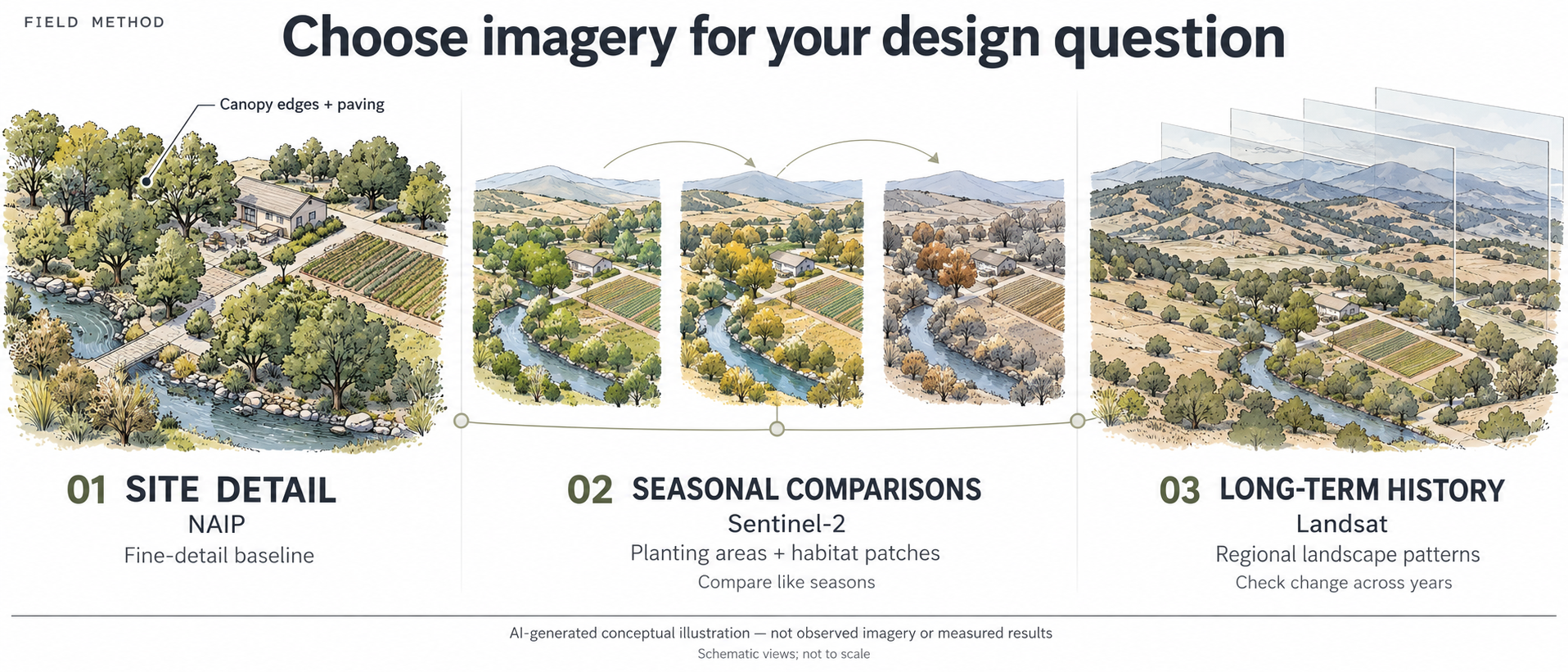
AI-generated conceptual illustration — not observed imagery or measured results.
- Define the project question. Are you studying a canopy edge, comparing planting areas through the seasons, or screening regional change across years?
- Choose the scale and bands. Start with four-band NAIP for a detailed baseline, Sentinel-2 surface reflectance for seasonal comparisons, and Landsat surface reflectance for longer landscape histories. Check the actual product’s bands and native pixel spacing.
- Inspect acquisition dates and quality masks. Use capture metadata, not publication dates. Review clouds, cloud shadows, fill and saturation; a low scene-cloud percentage does not guarantee a clear site.
- Verify the interpretation in the field. Compare the imagery with site observations and maintenance or disturbance history before making a design decision.
The views are schematic and not to scale. The landscape is invented; it does not depict an actual San Diego site. Seasonal colors and layered historical views illustrate a workflow, not measured vegetation conditions or change.
Start with scale and purpose
NAIP is the practical fine-scale starting point. The USDA records checked here contain red, green, blue and near-infrared (NIR) bands at 0.6-metre pixel spacing. That detail helps interpret canopy edges, planting blocks and adjacent paving. It supports a detailed baseline, rather than a frequent seasonal series. Use the original four-band raster for analysis; an RGB screenshot or rendered map tile may omit NIR and alter pixel values. USGS NAIP overview
Sentinel-2 L2A is the stronger default for seasonal comparisons. Its surface-reflectance products offer blue, green, red and broad NIR at 10 metres; the red-edge bands, narrow NIR and shortwave infrared (SWIR) are at 20 metres. Those additional wavelengths support vegetation and moisture-related comparisons across larger planting areas, habitat patches and watersheds. Upsampling a 20-metre band to 10 metres does not create finer measurements. Copernicus product documentation
Landsat supports landscape history. Landsat 8 and 9 provide 30-metre reflective bands, including NIR and SWIR. Their individual 16-day repeat cycles are offset by eight days; clear observations depend on actual conditions. For earlier history, extend the study into older Landsat missions with attention to sensor differences. The 15-metre panchromatic band does not turn the Level-2 multispectral measurements into native 15-metre reflectance. USGS mission specifications · Collection 2 science products
An older local option deserves attention: SanGIS lists 2014 countywide 30-centimetre four-band imagery. Its 2023 offering is listed as three-band. Check band content, delivery costs and availability before substituting a sharper local aerial for a multispectral source.
Capture dates we verified
These are representative records, checked on October 10, 2026. Satellite searches used a small footprint around San Diego city within a September 1–October 10 window. They establish local overlap, not a countywide completeness audit.
- NAIP, western San Diego: tile m_3211707_sw_11_060_20240506, containing 32.9° N, 117.2° W, records May 6, 2024 in its QQDATE field. The original tile reports four bands and 0.6-metre pixels. USDA record
- NAIP, near Ramona: tile m_3311658_sw_11_060_20240506, containing 33.05° N, 116.86° W, also records May 6, 2024. This corroborates another location, without assigning that date to the whole county. USDA record
- Sentinel-2B L2A, tile 11SMS: October 9, 2026, catalogue sensing timestamp 18:32:59 UTC, processing baseline 05.13; tile cloud summary 2.25%. Copernicus item
- Landsat 9, path/row 040/037: October 9, 2026, catalogue timestamp 18:22:41 UTC; scene cloud 3.10%, land cloud 0.92%. USGS item
- Landsat 8, path/row 040/037: October 1, 2026, catalogue timestamp 18:22:34 UTC; scene cloud 11.18%, land cloud 0.20%. USGS item
The timestamps above are catalogue fields, not verified per-pixel exposure times. Cloud percentages describe whole satellite tiles or scenes, not the project site. Landsat 9’s identifier also contains October 10, its processing date; that is not another capture. A mosaic’s year or publication date likewise cannot date every pixel. A NAIP quarter-quad date does not prove every source exposure happened that day; precise parcel studies need acquisition footprints or source metadata.
Local metadata can conflict. A SanGIS layer titled NAIP_2020_IR_3Band describes summer 2018 imagery. That unresolved discrepancy is a reason to check original acquisition records before using the layer in a dated comparison.
Read the values before calculating an index
NAIP’s checked tiles store 8-bit image values. Do not assume these are calibrated surface reflectance or directly comparable across flights. Quantitative cross-date work needs radiometric checks beyond a visually seamless mosaic.
Satellite L2 reflectance is unitless but commonly stored as scaled integers. Landsat Collection 2 surface reflectance uses DN × 0.0000275 − 0.2. The checked Sentinel item specifies scale 0.0001 and offset −0.1; Copernicus explains how offsets and quantification values are recorded. Read the actual product metadata and check whether the software already applied them. Ignoring an additive offset can change NDVI.
Mask fill, clouds, cloud shadows and saturated pixels before analysis. Inspect aerosol quality too. Use Sentinel’s scene classification and the Landsat QA layers, followed by a visual site check. A low scene-cloud percentage is only a search filter.
Make the comparison useful on the ground
A 10-metre pixel covers 100 square metres; a 30-metre pixel covers 900. A narrow planting strip may mix foliage, soil, roofing and paving in one measurement. That arithmetic explains why a regional greenness trend cannot identify which individual plant needs treatment.
For a first pass, draw the project boundary, check its original NAIP tile dates, then collect clear Sentinel observations from comparable seasonal windows. Retain the band list, acquisition date, processing version, quality mask and valid-pixel coverage with each result. Match coordinate reference systems, datums, units and pixel grids before overlaying layers; orthorectification does not make an image survey-grade. Test interpretations against field observations and recent maintenance or disturbance history.
For a combined satellite time series, NASA’s HLS v2.0 applies harmonization on a common 30-metre grid. It is a useful alternative when consistency across sensors matters more than Sentinel’s native detail. We have not checked a local HLS granule here.
Keep reuse traceable
NAIP and Landsat data are public domain; retain their agency attribution. Copernicus Sentinel’s legal notice permits broad reuse and requires source notices, including identification of modified data. Data permissions do not automatically license website text, illustrations or software. This note links to documentation and metadata; no third-party code or imagery is republished.
Sources
- USGS NAIP archive overview
- USDA NAIP collection and license
- NAIP Data Dictionary
- m_3211707_sw_11_060_20240506
- m_3211707_sw_11_060_20240506 native raster metadata
- m_3311658_sw_11_060_20240506
- m_3311658_sw_11_060_20240506 native raster metadata
- Sentinel-2 product specification overview
- S2B_MSIL2A_20261009T183259_N0513_R027_T11SMS_20261009T234230
- Legal notice on the use of Copernicus Sentinel Data and Service Information
- Landsat 8 specifications
- Landsat Collection 2 Level-2 Science Products
- LC09_L2SP_040037_20261009_20261010_02_T1_SR
- LC08_L2SP_040037_20261001_20261009_02_T1_SR
- Landsat Level-2 scale factors
- Landsat 8-9 Surface Reflectance Quality Assessment
- Are Landsat data in the cloud still public domain
- SanGIS Aerial Imagery Request Form
- SanGIS NAIP_2020_IR_3Band service metadata
- Harmonized Landsat Sentinel-2 Data Products
Try a relevant tool
These tools support site review and design studies. Read each tool’s stated capabilities and limits before use.
Explore Landscape Workspace