1972
Parque Barigui, Curitiba
City of Curitiba; linked to the 1965 master plan prepared by IPPUC · Curitiba, Paraná, Brazil
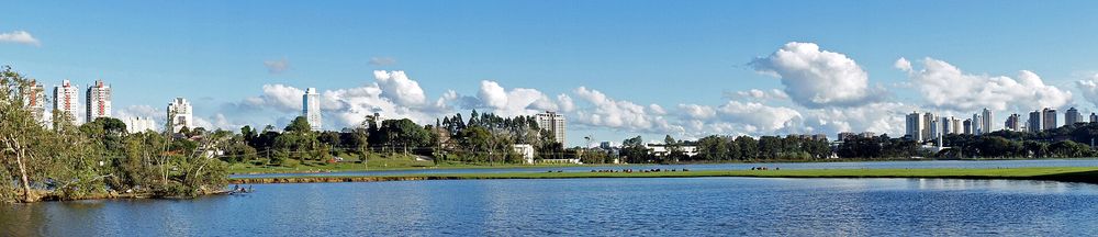
A park created in 1972 on the Barigui River as a preservation area and to contain its floods. Its history is tied to Curitiba's 1965 master plan, which called for linear parks beside the city's rivers to regulate high water.
How it came about and changed
- 1965
Curitiba's first Plano Diretor, prepared under the newly founded IPPUC (Instituto de Pesquisa e Planejamento Urbano de Curitiba; Gazeta do Povo names Jorge Wilheim as responsible), called for large linear parks at strategic points along the rivers crossing the city to regulate high water and so avoid floods.13
- 1972
Parque Barigui was created in 1972, together with the São Lourenço and Barreirinha parks, reflecting the city's concern with drainage; it was intended as a large preservation area and to contain floods of the Barigui River. A city parks official quoted in 2010 linked it to the Plano de Preservação de Fundos de Vale (valley-floor preservation plan). The scholarly literature places the creation of most Curitiba parks in the 1970s administration of Mayor Jaime Lerner.324
- 1972 onward
The Barigui became one of a chain of parks along the river, which also includes the Tanguá, Tingui, Cambuí, Guairacá, Mané Garrincha, Mairi and Yberê parks and, at its mouth on the Iguaçu, the Reserva do Bugio wildlife refuge.1
- 2009–2013
The park covers about 1.4 million m2 and is described as Curitiba's most visited park. In 2009 the city's first outdoor gym (academia ao ar livre) was installed there, the start of a citywide programme that numbered 125 such gyms by 2013.42
- 2010 (management)
The park is managed by the municipal environment department (Secretaria Municipal de Meio Ambiente, Departamento de Parques e Praças). The surrounding land is zoned ZR-1, limited to residential houses of at most two storeys, and nearby property is reported to have gained value since the park was established.2



Approvals and legal steps
- 1965 Curitiba's Plano Diretor (master plan), which provided for linear parks along the rivers for flood regulation.1
Funding
No source opened states who paid for the design and construction of the park or any amounts. Search snippets mention a city news article saying the military-era federal government did not fund leisure projects when the park project was presented in 1972, but that page could not be opened, so it is not used.
People
- Prefeitura Municipal de Curitiba Created and manages the park (Secretaria Municipal de Meio Ambiente, Departamento de Parques e Praças)
- IPPUC (Instituto de Pesquisa e Planejamento Urbano de Curitiba) Technical team of the 1965 Plano Diretor that proposed linear river parks
- Jorge Wilheim Responsible for Curitiba's first Plano Diretor (1965), per Gazeta do Povo
- Jaime Lerner Mayor of Curitiba in the 1970s, under whose administration most of the city's parks were created
Sources for this page
- Prefeitura Municipal de Curitiba, Aqui passa o Barigui
- Gazeta do Povo, Parque Barigui: imóveis valorizados (Fabiane Ziolla Menezes, 8 May 2010)
- Gazeta do Povo, Inovações no planejamento urbano trouxeram fama à capital (2011)
- Universidade Tuiuti do Paraná, A qualidade de vida nos ambientes urbanos: parques e academias ao ar livre no município de Curitiba (Mariana Ciminelli Maranho), Tuiuti: Ciência e Cultura n. 46, 2013
- Wikidata, Parque Barigüi (Q10344895)
Researched on 2026-11-19 from the sources listed; a fact that could not be confirmed in a source was left out. Pictures are public domain or under an open licence, credited as their file page asks.
The question it brings · interpretation
Where a river crosses your project, how much land could be given to rising water as usable park, and what would that land be used for when dry?
Each question is Field Method’s interpretation, not a claim made by the source.
The date
Year the park was created and opened, per a Curitiba newspaper and a property guide; the city's own park pages could not be opened.